JOHN PASCOE FAWKNER'S CO-OPERATIVES NORTH WEST OF MELBOURNE, VIC., AUST.
This journal arose from my journal about Pascoe Vale and Strathmore. I wished to mention the pioneers on his grants obtained on behalf of his co-op. members in areas outside the scope of that journal.
The following comes from my EARLY LANDOWNERS:PARISH OF TULLAMARINE. Sections mentioned are in the parish of Tullamarine. As maps are not able to be pasted here, I will give Melway references for the plots of land bought by the co-operative members and transposed on my trusty old Melway.
Only purchasers in section 10 will be included in the surname list here. Surnames of members of Fawkner's co-ops involved in the purchase of land in sections 13 and 6/7 will appear in the surname lists of journals entitled J.P.FAWKNER'S CO-OPS,SURNAMES LIST, SECTION 13 TULLAMARINE and J.P.FAWKNER'S CO-OPS,SURNAMES LIST, SECTIONS 6 AND 7 TULLAMARINE.
Unfortunately I have wasted many hours in the past, retyping surname lists from which the majority of names entered have disappeared after a while. This seems to occur when there are more than about 25 names, and there are 32 for section 10, so the surname list journals are an insurance policy.
SECTION 10.
This 448 acre section was bought by John Pascoe Fawkner, as chairman of the Victoria Cooperative Freehold Land Investment Society, with money paid in by those who wanted to buy land. Upon the conveyance of each member?s land an additional 10 shillings was paid to Fawkner. The 10/- payment, probably to cover stamp duty, was also paid on conveyance of Fawkner?s land at East Keilor, in sections 13 and 7 in the parish of Tullamarine and at Hadfield and Coburg.
Fawkner?s land was generally broken into lots of about 6 acres, probably to make it possible for even the poorest yoeman farmer to own his own land. However the lots must have proved too small and they were to become consolidated into large farms such as Shelton at East Keilor, Glenalice in section 13 and Loves? dairy in section 7.
Memorials concerning section 10 land rarely mention lot numbers; only those for Boone and the Presbyterian church land do so.
Andrew Lemon mentions the above school on P. 38 of his Broadmeadows history but assumes that it was two miles west of Broadmeadows. It is likely that this was the .3 acre site at the north west corner of lot 14 on section 10. This was conveyed into the trust of J.P.Fawkner, Henry Langlands, David Smith and Dugald Stewart on 15-10-1855 (70277). Rev. Reid?s argument that the parish was intersected by creeks (always flooded in the rainy season) makes me believe that he was talking about Tullamarine Island rather than the area near John Grant?s ?Seafield? where a school also commenced in 1959. Tullamarine Island School 619 operated 1-7-1859 to 30-4-1865 and 3-12-1875 to 31-8-1882. (2nd period probably on the site on Bulla Park mentioned by I.W.Symonds.)
POSTSCRIPT. Although Henry Langlands was a trustee, it is likely this school was on section 10. Langland's children,if they attended this school would have had to walk from 5 B-C6 to 3 E2, crossing Deep Creek!
The land bought from Fawkner by the following is shown in the section 10 subdivision map.All map references are for Melway.
LOCATION AND PURCHASERS OF LOTS IN THE SUBDIVISION OF SECTION 10.
Vol. Fol.; Purchaser; Date; Lot number(s); Location in Melway.
S 654; Edward Pope; 27-11-1852; 7; 3 B 2-3 and road frontage* in western third of C3. The south west half of the northern part of the horseshoe bend, now entirely part of the Organ Pipes National Park.(* The road once led to a ford over Deep Creek that Harriet Sharp would have used, but it now finishes at the south east corner of lot 7.
S 736; Thomas ;27-11-52; 12, 13; Between Loemans Rd and the western two thirds of the green part of the organ pipes park in the western half of 3 D 3 and eastern half of E3. The Coopers Rd corner is over Loemans Rd from the midpoint of lot 11 and lot 12 is to the east.
S 737; Thomas Collins; 27-11-52; 2; The words ORGAN PIPES NATIONAL in 3 D4 just fit in between the north and south boundaries of lot 2. Its eastern boundary is that of the park.
T 292; Elizabeth Sweetnam; 24-12-52; 23; Top third of the left half of 3 E1 north east of the bend in Coopers Rd. Continuations north and east of the lines of Coopers Rd indicate the west and south boundaries.The eastern boundary of lots 1, 2, 4, 13, 14, 21,22, 23,30,31, 40, 41, 44 and 45, also the eastern boundary of section 10, can be ascertained by extending the eastern boundary of the Organ Pipes National Park(in 3 E 3-4)to the north. If you cross from map 3 to map 176 properly you'll find that the north east corner of section 10 is in the middle of the horseshoe bend in 176 E-F 11.
T 879; William Pollock; 20-12-52; 31; central ninth of 176 E12,its southern boundary an eastern continuation of Coopers Rd and its eastern boundary discussed in bold type under lot 23.
T 980; John Dwyer; 23-1-53; 4;the almost rectangular part of the park in 3 D-E3 extending south to include a third of the incredible formation,the organ pipes.
U 191; Hugh Cameron; 10-12-52; 10; a triangular block in 3 C2, and D 2-3, bounded on the north west by the road that led to the ford,on the south west by the park,its eastern boundary indicated by the west boundary of the rectangle-like part of the park in 3 D4 and continuing to the private access road that runs west from Loemans Rd.
U 195; George Lewis; 10-1-53; 6;southern part of the horseshoe bend in 3C3, with its north east boundary being a continuation (across the road to the ford)of Pope's (lot 7.)
Although the combined maps 3 and 176 map has been attached, I will continue my description of the various purchases in case any descendants wish to mark the boundaries of their ancestors' land on their own Melway.
U 437; Thomas Biggin; 27-11-52; 15; right third of top third of 3 D2.
V 918; John Beasley; 10-12-52; 9; 3 C-D2 between road to the ford and Jacksons Creek.
V 927; Edward Jennings; 26-3-53; 26; top right corner of 3 C1 between Jacksons Creek and Cooper Rd.
W 27; John Christian; 2-4-53; 18; South of lot 26 in small horseshoe bend in 3 C1.
*W 328; Fred. Anthony Thies; 10-12-52; 8;north east half of horseshoe bend protruding into 3 B2 with a frontage to the road to the ford in 3 C3.
3 144; Nicholas Close; 24-10-1853; 27 ;176 C12 fronting Jacksons Creek and the n-s and e-w parts of Cooper Rd and adjoining lot 26 halfway to the bottom of 176 C12.
3 367; Edward Blair; 8-11-53; 11;middle longitudinal third of 3 D 2-3 (between the private access continuing the line of Loemans Rd to the west and the western third of the almost rectangular part of the park north of Jacksons Creek in 3 D-E.
3 407; John McKechnie; 28-10-53; 24; fronts the northern side of the eastern half of Cooper Rd in 3 D-E 1.Northern boundary just above "private access".
4 764; Robert Lechmere; 10-1-53; 20; right third of (almost) bottom third of 3 D1. Frontage to half of the n-s section of Cooper Rd and the eastern third of the e-w section.
4 948; Stewart Davidson; 3-12-52; 37; top right corner of 176 C 12 plus a triangular part in a small portion of C-D 11 where the northern boundary heads east nor' east to meet the eastern boundary (a continuation of the last n-e section of Cooper Rd) at Jacksons Creek. The southern boundary is just south of the easternmost part of the curve near the end of the private access.
5 846; Kezia McCurdie; 29-12-53; 22; Not quite the middle latitudinal third of the west half of 3 E1 between Cooper Rd and the east boundary of section 10.
6 801; John Hughes; 1-12-52; 21; the bottom third of 3 E1 between McCurdie's lot 22 (previous entry)and lot 14 (Cavour Country Club.)
6 802; George Davis; 1-12-52; 32; Middle latitudinal third of 176 D 12 (eastern three eighths)and E12 (western quarter.)
6 805; Alfred Monk; 26-1-54; 30; bottom third of left half of 176 E12. Northern boundary is an extension of the Cooper Rd line to the east.
6 827; William Bedford; 20-12-53; 34 (northern half.The location of the whole of lot 34 is given here.
The southern boundary is just south of the e-w end of Cooper Rd (or it might be the southern boundary because the number of links in the sketch of title,or my transposition is slightly out;I'm discussing a difference of one millimetre on Melway!)The northern boundary is about four fifths of the way to the top of 176 C12 and the eastern boundary is a continuation of the last n-s section of Cooper Rd. William Burrell (below) bought the southern half including (or fronting)the end of Cooper Rd.
8 465; Jn Hy Broughton; 10-12-52; 28; bottom third of (a bit more than) the left half of 176 C12. North boundary is an eastern extension of the e-w section of Cooper Rd.
12 329; William Burrell; 31-12-53; 34 (southern half fronting or including the end of Cooper Rd ; the location of the whole of lot 34 is given under the William Bedford entry (just above.)
23 135; Ben. Escott Cozens; 10-12-52; 19; middle longitudinal third of 3 D1 fronting the south side of Cooper Rd and extending south halfway to the private access between Loemans Rd and the creek.
26 995; B.Brookman; 10-12-55; 25; top left corner of 3 D1 having Cooper Rd as its south and west boundary. North west corner indicated by the E in COOPER RD in 176 D 12.
25 46; Charles Boone; 26-1-54; 5 3 38-45.
Lot 5. 3C-D3. The part of the park south east of the road to the ford between the diagonal park boundary with a parallel south west boundary and the ROSETTE ROCK just inside its southern corner.
Lot 3. 3 D-E 3-4 east of Jacksons Creek. The southern two thirds of the ORGAN PIPES are inside its northern boundary and the south boundary is just above ORGAN PIPES in 3 D4.
Lots 38-45. Top third of 176 D12 and left half of top third of 176 E 12, and north to Jacksons Creek.
30 303; David Smith; 31-8-55; 36; the horseshoe bend in 176 B 11-10 with a southern boundary just inside 176 C and D11.
*30 331 Repeats W 328 correcting errors.
34 804; Alex. Cameron; 10-12-52; 16; same western and eastern boundaries as lot 19 to the north,that is lines leading (magnetic)south from points one third and two thirds of the way along the e-w section of Cooper Rd. Fronts the private access and goes halfway north to Cooper Rd.
70 277; Trustees 15-10-58; 1/3 acre; 14. Cavour Country Club,3 E2. Was this Rev.Reid's school?
161 44; William Jolley; 14-6-1866; 17; western third of 3 D1 part 2 fronting Cooper Rd and the private access leading west from Loemans Rd. The western boundary was a southern continuation of the n-s part of Cooper Rd at the top of 3 D1.
168 702; John Jones; 10-12-1852; 1; 3 D4,the south west portion of the Organ Pipes National Park with its northern boundary between the words NATIONAL and PARK on the map.
COPYRIGHT MELWAY PUBLISHING PTY. LTD. REPRODUCED FROM MELWAY EDITION 27, WITH PERMISSION.
The lot numbers as shown above were unknown until I was trying to establish the locations of farms owned by the Tates and Randalls. Luckily a plan of Fawkner?s subdivision of section 10 was included in the sketch of title for Application 12224
(by Paul Tate in 1879.)
The plan showed that Fawkner?s index did not include details about the sale of three lots, unless I missed the entries in my transcription.
LOT 35 WAS BOUGHT BY HENRY JOLLY (285 117).
LOT 29 WAS BOUGHT BY COGAN BRUMBY (6 228).
LOT 33 WAS BOUGHT BY THOMAS HORLEY (HORTEY?)
Joll(e)y?s purchase of lot 35 was probably not memorialized until 1880 when Letitia Roy Smith (David?s wife) applied for title, stating that she bought it from Henry Jolley for 90 pounds on 26-3-1856 (Application 13198).
It is obvious that the purchase of lot 33 was never memorialized. Some proof of the purchase must have been provided in application 13537.
In superimposing the lots onto Melway maps 176 and 3, I have used the dimensions given in memorials but I have had to show with a dotted line that the south- west corner of lot 42 was at the bend in the river.
SECTION 10 FARMS.
Abraham Hodgkinson?s farm consisted of lots 7, 8 and 9. The part of it that is now part of the park passed to his widow Harriet, who also received the grant for allotment 7A of section 5, Holden on 1-12-1875. (Harriet then lived in Holden, so the farm on lots 7 and 8 was then called the ?Old Farm?.) Harriet?s second husband, William Sharp, bought lot 6* on 29-6-1865, so Harriet (a daughter of Thomas Faithfull) would have toiled on lots 6, 7, 8 and 9 as well as Starr Grove. The rest of Abraham?s farm was sold to Harry Mildenhall, husband of Harriet?s sister. Henry sold this to George Randall for 75 ? pounds on 3-4-1862.
*Lot 6 was sold to Sharp by R.G.Nichols (who had bought it from Lewis on 23-8-1854 for 120 pounds) .Was this George Nicholls who married Harriet?s sister Jane? Nichols sold to Sharp for only 60 pounds.
COPYRIGHT MELWAY PUBLISHING PTY. LTD. REPRODUCED FROM MELWAY STREET DIRECTORY EDITION 27 , WITH PERMISSION.
Allotment B of section 5 in Holden was granted to Paul Tate and the other executors of the will of C. Rhodes. Ed Fanning does not believe that it became part of Pleasant Vale. Paul Tate probably gained title to lots 35 and 27.
George Randall also bought lots 11-15 from Thomas Fraser on 20-11-1861 for 325 pounds (112 484). It is likely that Randall also bought lots 10 and 16 from Fraser. Ed Fanning says that the 108 acres that Alf Randall had after Hall had bought this section 10 farm was in the western quarter of 11B.
William Bedford sold the southern half of lot 34 to David Smith for 40 pounds on 12-3-1861 (6 827). He had bought lot 3 from Boone for 10 shillings on 3-4-1855 and lot 2 from Collins on 12-3-1856 for 112 pounds. He later added lot 1, purchased from John Jones for 129 pounds on 25-1-1867 (Application 26569).
Henry Ernest Hall applied for title to lot 4 (Application 27053) and then Harriet Sharp?s old farm and lot 6 in 1891. Application 40141 shows Hall in possession of lots 1-13 (all the section 10 land south of the line of Loemans Rd) as well as lots 14 and 16. Ratebooks (1902, 1915) show that he owned 106 acres.
John Heagney bought 11B from the grantees but by 1882 Katherine and James Heagney were reduced to leasing Craigllachie from the O?Briens. Paul Tate had the western half of 11B and the Ritchies had the eastern half.
ABRAHAM HODGKINSON.
Abraham Hodgkinson was the 3rd mate on the ?Royal Consort? which left for Australia on 9-11-1843 and arrived on 18-2-1844. He was paid L8/19/6 for his duties, which indicates that he did not jump ship as many sailors did a decade later during the gold rush. On board as passengers were Thomas Faithfull 37, his wife Mary Ann 39, and their children: Harriet Ruby 19, Sarah Amelia 17, Henry 14, Jane 11, Moses 8, William 4 and Thomas 2. The Faithfull family must have soon arrived in this area for when their eighth and last child, Anne, was born on 9-6-1846 the birth was registered at Bulla.
Now it seems that Abraham Hogkinson, about 31 during the voyage out, was using his time off duty for more than sleeping. A certain 19 year old lass had caught his eye and he was to marry Harriet on 10-2-1850. Abraham was to live only nine years after his marriage but fathered eight children because he started early! Did they elope? The registrations of his childrens? births indicate his whereabouts before buying land on Tullamarine Island:
Ester b. Moonee Ponds* & d. Melbourne 1845, Maria b. Gippsland 1848, William b. Keilor 1849, Marian b.1851 and Sarah b.1853 at Jordans Creek (up Castlemaine way), Thomas b.1855 Tullamarine, Harriet b.1857 Flemington (may have needed special medical care for the birth), Abraham b.1860 Tullamarine (d.1861.)
(Moonee Ponds could have indicated that he was working for Loeman on Moreland, Robertson on La Rose or Fawkner on Belle Vue Park, leasing part of 23 Doutta Galla, working for Kenny on Camp Hill, McDougall etc on Glenroy, Peter McCracken on Stewarton, Coghill on Cumberland, Dewar on Glendewar, Greene on Woodland or Firebrace on Melford Station, i.e. anywhere near the Moonee Ponds Creek!
Several historians have made the mistake of assuming that ?Moonee Ponds? meant the present suburb.)
Anyhow, getting back to Abraham?s farm. On 25-2-54, Abraham bought Edward Pope?s allotment for 150 pounds (12 981). For an amount that was not entered in the memorial, he then purchased the neighbouring allotment from Frederick Anthony Thies on 4-5-1855. I have not been able to find the conveyance of John Beasley?s allotment, but Abe obviously owned this by 1-9-1855, when he mortgaged all three allotments to J.H.Brooke for 100 pounds (30 384).
On 30-7-1858, Abraham conveyed Beasley?s lot and the eastern part of Thies?s lot (which is not part of the Organ Pipes Park) to Henry Mildenhall for 125 pounds (66 695). Mildenhall became the husband of Sarah Amelia Faithfull, the sister of Abraham?s wife, Harriet. Abraham Hodgkinson died on 2-12-1859. In 1862, his widow married William Skill Sharp but Harriet again became a widow when William died on 4-8-1870.
On 15-7-1879, Thomas Hodgkinson conveyed Pope?s purchase and the western half of the lot originally bought by Thies (both now part of the park) to his mother Harriet Sharp for 140 pounds. (282 230). The memorial indicates that the title was converted (to Torrens?) in 1890 so details of further conveyance cannot be obtained for free.
Harriet Sharp died on 24-12-1885. Her will of 17-12-1885 left ?the old farm? (lot 7 and the western half of lot 8) to her daughter Amy Ann Sharpe and ?East End Farm?, her present homestead (allotment 7A of section 5 in Holden) to her son, John Sharpe. Thomas Hodgkinson was appointed as Amy?s trustee until she turned 21.John Sharpe, her sole executor, specified on 31-3-1886 that the Holden farm consisted of 36 99/160 acres and the old farm of about 31 acres. (See 11A re spouses of Harriet?s kids.)
DAVID SMITH.
David Smith purchased lot 36 in section 10 from Fawkner. He later acquired the nearby lots originally purchased by Burrell (1854), Cozens (55), Bedford (61) and William Jolly (67). His wife Letitia Roy Smith bought Henry Jolly?s lot 35 on 26-3-1856. David was one of the four trustees for the Presbyterian land on lot 14.David also owned John Byrnes? old farm of about 150 acres (between Overpostle and the westernmost quarter of 11B) from 1862 until he sold it to Paul Tate on 18-3-1876. Letitia sold about 12 acres to speculator, Aaron Waxman, on 17-12-1879.
SECTION 13.
As the Mansfields owned land in both allotments, details of both allotments need to be read in conjunction with each other. See J.P.Fawkner?s 80 lot subdivision of 13B and the southern half of 13A superimposed on Melway map 4.
CROWN ALLOTMENT A.
This allotment consisted of 492 acres and was granted to John Pascoe Fawkner and George Coghill in December 1850.On 28-9-1852 the allotment was bisected with Coghill taking ownership of the northern half and Fawkner the southern 246 acres. Fawkner then subdivided this land and 13 B (south of Mansfields Rd). The original purchasers of this land are shown on Melway map 4. Lots consisted of about 6 ? acres.
Purchasers in 13 A whose names persisted in the area for many years were George Emerson (family associated with the area at the start of Loemans Rd), William Trotman (family associated with land between the two parts of Waltham, Glenarthur, Springfield and Greenan, all on the northern side of Somerton Rd at Greenvale), and Donald Gray (land retained until 1915 at least by Agnes).
George Coghill mortgaged his property Glencairn (the northern half of 13 A, 17B and the part of section 16 s/w of Bulla Rd) to Henry Miller for 2100 pounds on 9-6-1856. Perhaps he needed the money to build his boiling-down works on Glencairn.
Most of the Fawkner?s subdivision blocks, and obviously Coghill?s half were eventually purchased by David Mansfield. In 1891, David had obviously sold two properties of 343 and 320 acres to Herman who was listed as the owner with nobody listed as occupant. David?s 320 acres farm was obviously Roseleigh plus 50 acres and the 13 acres later added to Glenalice, and the 343 acres was the farm given to Walter later on with the addition of 13 acres.
G.W.Taylor (Gladstone Park and Chandos) and the Essendon Land Tram and Investment Co. (Crotty and Delahey land on both sides of Fosters Rd), had been forced to relinquish their land as well as payments already made when the depression struck. The Hermans (Thomas and Marks) who had also bought Gowrie Park and much land near the Bulla cemetery and shire hall, would have suffered the same fate.
Coghill?s half of 13A (246 acres) and Fawkner?s lots 1-14 of 6 acres 12 perches each (88 ? acres plus the private road 50 links wide and 11620 links long running east-west 1220 links north of Mansfield Rd, another 5.8 acres), became his son, Walter?s Glenalice. The above adds up to 340.3 acres, fairly close to the acreage of the first farm sold to Herman by David Mansfield. The magnificent duochrome brick Glenalice near the west end of the runway would have been demolished in about 1965 at about the same time as the Inverness hotel. Roseleigh of 257 acres, owned by Walter?s brother Ernest, was partly north of Mansfields Rd, but its homestead (still standing) and much of its land were on the south side.
A 28 acre block owned by T.W.Taylor/Emerson originally and later occupied by Charles Farnes (1860?s) John Duncan McFarlane of Worrough at Keilor (1922-3) and Kevin Ernest Butler (1946-7) was sold for the jetport C 1961 by the Butlers. This block, lots 27-29, fronted north side of the east end of Mansfields Rd. The easement granted to Walter Mansfield in David Mansfield?s will of 1903 was probably on the western boundary of this 28 acre block. (See section 14 about what I think is a wrong assumption that Samuel Mansfield owned Gowrie Park.)
By 1946-7, the Mansfields had gone, their land having been bought in equal halves of 312 acres. Walter?s Glenalice was sold in 1939 with the clearing sale on April 12 bringing poor prices such as 5/- for a draught horse.
James Mackie Smith, a chemist according to Keith McNab, owned Roseleigh and Charles William Willers owned Glenalice. In 1950 or before, P.J.Shelley purchased Roseleigh, which was mainly in 13B but extended 1020 links north of Mansfields Rd. The Commonwealth purchased his 115 acres in 13 A in 1961. This 115 acres probably consisted of lots 15-26 of Fawkner?s subdivision (12 x 9 a. 1 r. 38 p. = 113 acres 3 roods 16 perches). Walter Murphy was trying to persuade the select committee in 1963 and 1970 that the remaining 186 acres should also be purchased.
By 1961 a Mr Finchett had bought Glenalice of 357 acres and sold it for the jetport.
LOTS PURCHASED BY FAWKNER'S CO-OP. MEMBERS IN 13A.(Lot No.; Name; Area; Document; location on Melway.)
14. James Bullied. (Volume 19, folio 934.) 4 B- small part C, fronting south half of eastern extent of horseshoe bend to Perimeter Rd.
13, 12. William Warr. 18 acres 25 perches. (Volume 4, folio 460.)The rest of 4 D2, middle latitudinal third.
11, 10,9, 8, 7. Correction fluid. I'd forgotten to amend what I'd written and, alas, I no longer have my notes.
North east corner of 7 just west of south corner of west end of runway.
LOTS 6-1 FRONT THE SOUTH SIDE OF THE RUNWAY BUT BECAUSE THE NORTHERN BOUNDARY IS MAGNETIC EAST-WEST,RATHER THAN BEING TRUE EAST-WEST AS THE RUNWAY IS, THE NORTH EAST CORNER OF LOT 1 TOUCHES THE BOTTOM OF 4 H2 AT A NORTHERN CONTINUATION OF McNABS RD.
6. Charles Snooks. (V.2 f.226.) Small parts E-F 2-3.
5. William Lees.(V.3 f.143.)Small parts F.2-3.
4, 3, 2, 1. William Trotman. F-G 2-3 and H3(top half, to corner mentioned above in bold type.)
THE SOUTHERN BOUNDARY OF LOTS 15 TO 29 IS MANSFIELD RD,THUS MELWAY REFERENCES MEAN NORTH OF MANSFIELDS RD. THEY ADJOIN LOTS 14-1 ON THE NORTH.
15-19. Donald Gray. (V.2 f.639.) Projection in 4 A2 to western quarter of D3.
The part of Mansfields Rd climbing up from Deep Creek (where there were good kaolin deposits)was called Gray's Hill. Malcolm Ritchie of Aucholzie, adjoining Fawkner's subdivision on the south, married a Gray girl.
20, 21. Correction fluid. (V.64 f.332 and V.19 f.890), possibly Gray. 4 D3, part D4.
22.Thomas Brown. (V.2 f.429.) Almost left half of 4 E3. Includes gate 11.
No lot number but obviously 23. School. Almost right half of 4 E3.
24-26. Patrick (probably a given name)correction fluid. (V.2 f.88 written only on 25.)4 F3.
27-28. George Emerson. (V.96 f.92.) Left two thirds of 4 G3.
29. John Taylor. (V.29 f.197.) East to Farnes' corner,the corner of McNabs and Mansfields Rds.
THE LOTS SOUTH OF MANSFIELDS RD WERE IN 13B.
ALLOTMENT B (SECTION 13).
Consisting of 415 acres, this was granted to Fawkner in December 1850. He subdivided it, along with the southern half of 13 A. Original purchasers are shown on Melway map 4. Charles Nash bought the land now occupied by Broadacres Kennels and Cattery and his widow, Mary, still owned it in 1922 and used it to graze dry cows. Harry Nash?s widow, Olive still owned it in 1970. The Ritchie family added 110 acres of 13B to Aucholzie and David (and then Ernest) Mansfield seem to have had 186 acres if Walter Murphy?s details about the Shelleys? farm were correct. Patrick Murphy had Ritchie?s 110 acres in 1914-5 and much of the remaining 119 acres would have been John Mansfield?s Pine Tree Farm and part of his 205 acres (including the 83 acre Scone) which Alf Wright was leasing. In 1922-3, Christina Elizabeth Turner had 114 acres, probably Pine Tree Farm, which was between Roseleigh and McNabs Rd. In 1946-7, R.J.Gilbertson had 119 and 106 ? acres in 13 B, obviously having acquired Pine Tree Farm and 4 of the 110 acres being added to the 114. In 1914-5 James Miller, a mechanic, had 12 acres between Nash?s block and McNabs Rd and in 1922-3 Robert Miller had it. The 1914-5 acreages ,using Walter Murphy?s numbers, exceed that of 13B by 27 acres so it seems that Percy Shelley only had 160 acres in 13 B (and hence David and Ernest Mansfield).
CO-OP. MEMBERS AND THEIR BLOCKS IN 13B.(Lot No.;Purchaser;Area; Document;Location on Melway.)
The northern boundary of lots 48 to 30 is Mansfields Rd unless otherwise stated.
46-47. James Timms. Fronts eastern run of Deep Creek from the old ford in James Robertson's Upper Keilor
(west end of dotted line at the end of Mansfields Rd)with the south boundary starting from the bend to the south in 4 C3. Extends eastward just into 4 D3 and small part of C4.
47-48. James Amos. Eastern boundary is the southward-running part of Deep Creek in the bottom left corner of 4 C3. Small parts of C3 and 4. North east corner near the n in Airport Boundary.South of Timms' blocks.
44-43.Archbald McKenzie. Mansfield Rd boundary from the north east corner of Timms' purchase to two thirds of the way across 4 D3. Contains the private access road and goes south halfway to Bassett Rd.
42-41. John Cumming.Manfields Rd boundary from two thirds of the way across 4 D3 to halfway across 4 E3. Same depth as lots 44 and 43.
NO LOT NUMBER(S). Isaac Mansfield. (Volume Y folio 751.) Road frontage to Mansfields and Bassett Rds of about 600 links (6 chains or 120 metres, 6 mm on Melway) and a frontage to the West side of Panton Drive of 3000 links (30 chains or 600 metres.)
NO LOT NUMBER(S). Samuel Mansfield. (Volume X folio 838.)Same dimensions as Isaac's block but fronting the east side of Panton Drive.South east corner a touch east of the proposed runway.
33. John Mansfield. (V. folio 926.) Same dimensions as Issac and Sam's blocks. Northern half of east boundary adjoins Broadacres Kennels and Cattery in 4 G4 (in my 1999 edition but by 2007 acquired for airport expansion.)
This was almost certainly the farm that John called "Pine Tree Farm".
32, 31. Charles Nash. (Volume Y folio 419.) Broadacres Kennels and Cattery land.Frontage to Mansfields Rd of 260 metres, running east from a point 400 metres west of McNabs Rd. Top left two thirds of 4G4 extending southward halfway to the line of Bassett Rd.Charles and his son, Harry, used this land for spelling dry cows.
30.W.Spiers. Corner of Mansfields and McNabs Rd with frontages of about 140 and 300 metres. James Spiers was assessed by the shire of Keilor in 1868. Peter Spiers was assessed in 1900 on 101 acres that later became Bill Ellis's "Ecclesfield" and was probably Langlands purchase in Fawkner's subdivision of part sections 6 and 7.
The southern boundary of lots 49 to 62 is Bassett Rd.
49-51. James Robb. Horseshoe bend in 4 A-B 4 and first quarter of C4 on Bassett Rd frontage. Deep Creek is the western and most of the northern boundary.The northern boundary of this and other smaller blocks can be indicated by drawing a line from the westward flowing portion of the creek that forms Robb's northern boundary to the exact bottom right corner of 4 H4.
52. John Matthews. Roughly the next 120 metres to the east with the same depth as Robb's.
53. Thomas Clements.Ditto. Goes East to a planned (but probably never made) road that ran from Bassett Rd to meet Mansfields Rd at the western side of McKenzie's purchase to provide access for James Amos.
54, 55. Peter Nettleton. Next 280 metres to the east.Left two thirds of 4 D4. Same depth as Robb's.
56. James Jackson. Next 140 metres east. The rest of 4 D4. Same depth as Robb's.
57. William Gapper. Ditto. Left third of 4 E4, part 5.
58. Thomas Thomas. Ditto. Middle longitudinal third of 4 E4 part 5.
59. John Mansfield. Ditto. This block was 280 metres west of John's large block, 2nd east from Pantons Drive.
*Mansfield's large block on the west side of Pantons Drive.Proposed runway at north west corner.
*Sam Mansfield's large block on the east side of Pantons Drive.Proposed runway at south east corner.
* John Mansfield's large block for the next 140 metres east.
(* These blocks fronted both Mansfields and Bassett Rds.)
60. William Adams. Next 140 metres east. Left third parts 4 G4 and 5.
61. John Mansfield. Ditto. Middle longitudinal third of 4 G 4 and 5.
62. Arthur Millington. Last 140 metres to McNabs Rd. Right third of 4 G4 and 5.
The following tragedy led to my poem DEATH AT BERTRAM'S FORD.
Family Notices
The Argus (Melbourne, Vic. : 1848 - 1956) Tuesday 16 October 1906 p 1 Family Notices
... Colonist 53 years. MANSFIELD.-On the 15th October (accidently drowned), at Keilor, William John, beloved lim husband of Catherine Mansfield, and only surviving son of John Mansfield, of Tullamarine, aged 50 years also his eldest son. William John Mansfield Slans aged 7 years. "In ... 1116 words
This clash between brothers led to my poem THE WISDOM OF SOLOMON.The judge told them to shake hands and share a beer together (obviously not in the reporter's vicinity.) They were the best of friends from that day forward. (The late Wally Mansfield.)
An action was tried in the Supreme Court yesterday, before Mr. Justice A'Beckett and a jury of six, in which John Mansfield, of Tullamarine, sued his brother David Mansfield, of the same place, for damages for placing an obstruction across a road in Tullamarine, which it was alleged the plaintiff had a right to use. The plaintiff also asked that the obstruction should be removed from the road, and that an injunction should be granted against its re-erection. Mr. Topp and Mr. R. A. Smith appeared for the plaintiff, and Mr. Duffy and Mr. Bryant for the defendant. The plaintiff's case was that the road in question ran on one side of the defendant's land, and the defendant put a fence across it, and thereby prevented plaintiff from using it, or having access by it to the Deep Creek, to which it led. The defence was that the plaintiff had no right to the use of the road. The plaintiff produced evidence to show that he owned land in the district, and that his title to the land gave him also a right to use the road in question, the right being derived from the original owners of the land which constituted the road. After the jury had retired to consider their verdict, Sir Bryant stated that an affidavit had been filed with the judges associate by a clerk of the defendant's solicitors, in which the clerk swore that on the previous day he saw the plaintiff and his brother, Samuel Mansfield, enter a hotel together with one of the jurymen who was empanelled in the case. About a quarter of an hour afterwards the clerk went into the hotel and there saw John and Samuel Mansfield drinking and talking with the juryman, but when they saw the clerk they left the hotel by different doors.
Mr.Bryant therefore asked his Honour under the circumstances, to defer entering up judgment until an application could be made to the Full Court. Shortly after Mr. Bryant made the request, the jury returned into court with a verdict for the plaintiff with damages, 1s. Mr. Bryant then renewed his request, but his Honour stated that he did not think it was in his province to take any notice of the affidavit. He entered up the verdict for the plaintiff, damages 1s, with costs, and granted the injunction, the obstruction to be removed within one month. (P.4, Argus,20-11-1890.)
The road that David had closed could have been Panton Drive but might have also been several other subdivision roads that disappeared long long ago.
Bassett Rd is the northern boundary of lots 63 to 80.The south boundary of lots 63 to 80 can be pinpointed by extending the south boundary of the land shaded yellow in the 1999 and 2007 Melway (bottom of 4 F-G 5) to Deep Creek. This line was a continuation of Grants Lane and the boundary between the shires of Keilor (south) and Bulla (north);Fawkner's subdivision was entirely in the latter,as was the one in Section 10. The subdivision on the parts of section 6 and 7 west of Bulla Rd was entirely in the shire of Keilor, being south of Grants lane.
(These are listed from McNabs Rd to Deep Creek.)
63.John Mansfield. 200 metre frontage to McNabs Rd and frontage of 140 metres to west on the south side of Bassett Rd (which ran east to McNabs Rd.)The Grants Lane bridge (at the bottom right corner of 4 G5) was just across McNabs Rd from its south east corner.
64-65. Thomas Saunders. East to just inside 4 F5.
66-7.Thomas Threlfall. East almost to Panton Drive corner.
68-9.Graham Jameson. South west corner two fifths of the way across 4 E5.
70. James Figgins. South east corner almost three quarters of the way across 4 E5.
71. John Dewar. Southeast corner at the left boundary of 4 E5.
John Dewar might have been related to William Dewar, who founded Glendewar (Melway 5 C3 to E6.)
72-3. John Maglehose. South east corner three fifths of the way across 4 D5. In 1999 (with lot 74) comprised Mooreholme Kennels owned by Harry Moore and his wife, Val, both members of the reformed Keilor Historical Society. Harry was a gracious opponent in the 1974 Tullamarine ward election.
74.D.Hill. South east corner nine tenths of the way across 4 D5.The purchaser was possibly an ancestor of Stephen Hill who escaped death in the Mansfield tragedy at Bertrams Ford and was probably living at that time at Danby Farm at the east end of the east-west runway. William Mansfield was on Scone (Airport terminal site) at that time if I remember correctly. The two families had been neighbours for over 50 years by 1906.Like the McRaes, the Hills moved to St Albans.
75-78.Richard Thomas. 4 C5, parts B, D5 and C4.
79. No documents mentioning this were found. Possibly Richard or Arthur Thomas.
80. Arthur Thomas. Southern boundary 200 metres to Deep Creek and northern boundary (line of Bassett Rd)420 metres.
The north west corner of section 7 (and J.P.Fawkner's other subdivision in Tullamarine) was only one mile west along Grants Lane, past John Grant's "Seafield", from the south west corner of his section 13 subdivision.
------------------------------------------------------
Sections 6 and 15 were granted to John Carre Riddell an early squatter of Cairn Hill near Gisborne. Section 6 is west of "Gladstone" extending from Freight Rd to Bamford Ave with its western boundary roughly indicated by the northern part of Link Rd. Section 15 is between Bamford Ave and the creek,extending west to the Airport Terminal.
Section 7 was granted to J.P.Fawkner, as head of a co-operative, on 28-6-1850. Section 7 is the square mile west of section 6; its n/w corner is indicated by airport gates 33 and 34 and its s/w corner by the Quantas maintenance area.(1999 Melway.)
On 28-2-1851, Fawkner paid Riddell 217 pounds for the (almost) 107 acres of section 6 south west of Bulla Rd and Riddell paid Fawkner L 63/16/3 for the (almost) 64 acres of section 7 north east of the road.
SECTIONS 6, 7 AND 15.
Copyright Melway Publishing Pty. Ltd. Reproduced from Melway Ed. 27 with permission.
This map shows Fawkner?s subdivision of sections 6 and 7 south-west of Bulla Rd and Riddell?s north east of it. The location of the Beech Tree Inn on John Beech?s purchase is indicated by a dot. The lane starting at the north west corner of Beech?s land became known as Anderson?s Lane and the one starting between lots 7 and 8 was Conders Lane. Tullamarine State School 2613 was at the south west corner of lot 8. Ferguson?s purchase, labelled Stewart on the airport acquisitions map*, was actually 46 acres but a very old clerical error (reversing the digits) led the McNabs to believe that the rent and rates they were paying on 64 acres was justified.
See J.P.Fawkner?s subdivision s/w of Bulla Rd and J.C.Riddell?s subdivision n/e of Bulla Rd (superimposed on Melway map 5) on the next page.
On 28-2-1851, Fawkner paid Riddell 217 pounds for the (almost) 107 acres of section 6 south west of Bulla Rd and Riddell paid Fawkner L 63/16/3 for the (almost) 64 acres of section 7 north east of the road.
SECTIONS 6, 7 AND 15.
Copyright Melway Publishing Pty. Ltd. Reproduced from Melway Ed. 27 with permission.
This map shows Fawkner?s subdivision of sections 6 and 7 south-west of Bulla Rd and Riddell?s north east of it. The location of the Beech Tree Inn on John Beech?s purchase is indicated by a dot. The lane starting at the north west corner of Beech?s land became known as Anderson?s Lane and the one starting between lots 7 and 8 was Conders Lane. Tullamarine State School 2613 was at the south west corner of lot 8. Ferguson?s purchase, labelled Stewart on the airport acquisitions map*, was actually 46 acres but a very old clerical error (reversing the digits) led the McNabs to believe that the rent and rates they were paying on 64 acres was justified.
As much about the airport had changed between 1999 and 2007, I will provide new indicators for the north west and south west corners of Section 7, parish of Tullamarine (and Fawkner's subdivision.)
NORTH WEST CORNER of section 7. In Melway 5 B6, extend the line of Grants Rd west past Airside Rd to a spot above the A in Air (in Aust. Air Express). Make the western boundary by lightly drawing a line from this spot to gate 22 in 5 A10. Gate 22 is just south of the south west corner.
SOUTH WEST CORNER of section 7. Extend the north boundary of Trade Park in Melway 5 G-H11 (dotted blue line, formerly Post Office Lane) to a line joining the north west corner and gate 22.
PURCHASERS ON FAWKNER'S SUBDIVISION OF SECTIONS 6 AND 7.
SECTION 7. (Lot No; Purchaser; Document; location on Melway.)
18(and,apparently 19). David Beckinsale. North west corner with a 140 metre frontage east along Grants Rd to a road leading south which may have been called Spiers Lane. This road went south 280 metres(from the point where Service Rd and Grants Rd now meet) where it met an east west road at the north boundary of Menzies Cargo. David's eastern boundary then resumed 40 metres east along the latter road and was another north-south road that continued to gate 23 on the border of 5 A and B 10.David's south east corner was the top of the C in RESTRICTED AREA (5 B8.)
17, 16, 15, 14, 13. Henry Landlands. The rest of the Grants Lane frontage to Ellis's Corner ( the Bulla Rd corner, in Melway 5 D6.) The start of Grants Rd between Ellis's corner and Centre Rd has been renamed Melrose Drive for the benefit of motorists. These lots are bisected by Francis Briggs Drive. The southern boundary is the northern boundary of MENZIES CARGO extended towards Melrose Drive*, the east-west road referred to earlier.
(*The eastern 280 metres of this road bent about 15 degrees to the north from the eastern border of 5 C7.Apac Drive only extended east to halfway across 5 C7 in 1999 and it is likely that it now meets Melrose Dr at the corner of Landlands' land. It is likely that this was the 101 acre property owned by Spiers, Vaughan and Bill Ellis (who called it "Ecclesfield".)
AS OUTLINED IN COMMENT 1, I WILL NOW DEAL WITH THE BLOCKS BETWEEN THE WESTERN BOUNDARY OF SECTION 7, HEADING TO GATE 22 AND THE ROAD LEADING TO GATE 23.
20 (and, apparently 21).Charles James Watts.The north east corner is indicated by the west end of Apac Drive.The southern boundary is just below the westernmost six red arrows in 5 B8.
22. Joseph Allen. From Watts' southern boundary, three quarters of the way south to taxiway W in 5,parts A and B 8.
23. Timothy Francis. Taxiway W runs across its northern third and the southern boundary was where the (white) north western corner of the Qantas maintenance area touches the boundary between 5 A and B9.
24 and 25. Benjamin Bates. Includes the large Qantas (green) buildings with gates 22 and 23 being the south west and south east boundaries.
NOW BACK TO MELWAY 5 B7.
62 and 63. Mary Ann Vaughan. Northern boundary is that of Menzies Cargo taken east to the eastern boundary, which is the western boundary of Melbourne Gateway Facility. The east-west part of Airside Rd is its southern boundary.
64. J.Murphy. Melbourne Gateway Facility in 5 C7. The eastern boundary (and part of the southern) can be seen on Melway, a faint dotted line. I am prepared to bet that this was the pioneer at Diggers Rest in 1888, whose biography was in VICTORIA AND ITS METROPOLIS.I think his first name was John.
63, 12, 11. Richard Hartnett. Fronts Melrose Drive from the Apac Drive corner to the north west boundary of the airport staff car park in parts 5 D-E 7-8.The western boundary is the dotted line referred to as Murphy'seastern boundary. The southern boundary is a continuation east of Murphy's to the centre of the bottom of D7 where it bends to meet Melrose Drive at a right angle.
10, 9, 8. John Parker. Fronts Melrose Drive including the Airport Staff car park, the taxi holding area and LPG refuelling and carwash; Continues south to the Link Rd corner. From this corner, Parker's southern boundary,Conders Lane, ran (magnetic) west through the subdivision to meet the road which ran north from gate 23. Parker's purchase became part of James Love's dairy and the land for State School 2613 was bought from Love.
WE HAVE REACHED THE EAST BOUNDARY OF SECTION 7. BEFORE RESUMING AT LOTS 61, 60 AND 59, I WOULD LIKE TO SAY HOW HISTORICALLY INSENSITIVE ARE THE NAMES OF MERCER DRIVE (5 F7, D8) AND LINK RD (5 E9-10.) I presume these names were bestowed by the same boffins who destroyed Anthony Rowhead's bicentennial project to name airport roads after indigenous, European and aviation pioneers. Mercer Drive should be named after the Nash family and Link Rd should be named after the Parr family. Not one descendant of a pioneering Tullamarine family would disagree with this. Victoria St (of which Mercer Drive is a part) was named after the young Queen but every local called it Nash's Lane. Link Rd runs (on the section 7 and 6 boundary) through Sam Parr's "The Elms" to Bill Parr's "Annandale",just as the Oaklands Hunt used to do.
61, 60, 59.Mary Ann Vaughan. Like her lots 62 and 63 to the north, this purchase has a frontage on the eastern side of the road that runs from Menzies Cargo to gate 23. The northern boundary is the top of the pink area (to what used to be Perimeter Rd) in 5 B-C7.(Perimeter Rd is shown in the 1999 Melway.) Conders Lane,the southern boundary, was just north of taxiway W and can be shown by extending the east-west boundary of the pink area (at the top of 5 D9)to Melrose Drive and west to touch the intersection of the entry to the Qantas maintenance area and taxiway W. The boundary with lot 58 goes from the bend (south of the Melbourne Gateway Facility)in the pink area's boundary to the middle of the bottom of 5 C8.
58. Frederick Plumridge. East of Mary Ann Vaughan's lot 59. North east corner is at the junction of C and D 7 and 8. Fronts the north side of Conders Lane.
57 and 56. E?.M.Dyne. Left half of 5 D8. Bisected from north west to south east corners by border of yellow and pink areas.
55. M.J.McCulla. Triangular block in east side of 5 D8 and part E8,the north eastern boundary being parallel with Melrose Drive. Between Lot 55 and Melrose Drive were John Parker's lots 10,9 and 8 which were discussed earlier.
CONDERS LANE LEFT BULLA RD (MEROSE DRIVE)AT THE LINK RD CORNER AND ANDERSON'S LANE WAS OPPOSITE WRIGHT'S LANE (LATER HEAPS' LANE AND NOW SPRINGBANK ST), ALSO RUNNING (MAGNETIC)WEST TO THE LANE LEADING TO GATE 23. BETWEEN THESE SOME PROPERTIES FRONTED BOTH LANES AND THEY WILL BE SO DESCRIBED. (Anderson's Lane was at a right angle to Bulla Rd before turning west at the back of the Airport Club.)
47, 48, 45, 46. Edmund Parker. 5 B9. Fronts the three lanes.
49 and 44. D? Carroll. (Volume M folio 482), 20 acres 2 roods. Fronts both lanes. West half of 5 C9.
50,51. C.C.Horrett. (Volume M folio 722.) Top half of 5 C-D9 including part of South Centre and Cargo Rds.Fronts Conders Lane.
52, 53, 54,7. John Gibbs*. (Volume 32 folio 433.) Top half of 5 D-E9 east of Cargo Rd. Fronts Conders Lane.
43,42, 41. H.W.Cass. (Volume M folio 505.)Fronts Andersons Lane. 5 C-D 9 (bottom half), 10 (top third).
40-39. John Gibbs*. (Volume 32 folio 433.) Fronts Anderson's Lane. Gate 27 was near its south west corner and it went east three quarters of the way to Link Rd where Gibbs' two purchases adjoined "The Elms".
THE FOLLOWING LOTS WERE BETWEEN ANDERSON'S LANE AND THE SECTION 3 AND 7 BOUNDARY, POST OFFICE LANE (THE NORTHERN BOUNDARY OF TRADE PARK, EXTENDED EAST TO MEET THE NORTH SOUTH LANE AT GATE 23.)
26-28,part 29. John Ferguson.(Volume M folio 620.) 41 acres.Top half 5 B-C10.The reason it was only part of lot 29 was that the east half of the parking area north of building 48 was reserved as a waterhole. The waterhole and a lane leading to it from Andersons Lane would have consisted of 5 acres making a total of 46 acres,which was recorded in Keilor rate books as 64 acres for almost a century and only corrected during airport acquisitions circa 1960.
30. Name not recorded on my Melway because of insufficient space and I no longer have my notes.. (Volume M folio 157.) 10 acres. Roundabout at the Operations/Sth Centre Rd is the middle of the south boundary and gate 26 is the north west corner.
31, 32. George Scarlett. Bottom half of 5 D10.
33, 34, 35. Benjamin Bates. Bottom half of 5 E10. Lot 35 was actually in section 6.
SECTION 6.
THERE WERE ONLY THREE PROPERTIES IN THE SMALL PART OF SECTION 6 THAT WAS ON THE SOUTH WEST SIDE OF BULLA RD.
5, 6, 38. I was so excited to find the boundaries of "The Elms"that I forgot to write the purchaser on my Melway.It might have been Ann Parr, the widowed mother of James Henry and grandmother of Cr Bill and Sam. Link Rd runs through The Elms following the section 7/6 boundary as it turns south. Probably about a quarter of the 31 acres would be in section 7.The southern boundary is the east -west part of Anderson's Lane. Surrounds Bengrey's block.
Lot 4? George Bengrey. The Airport Club. North Corner of Anderson's Lane.
36. John Beech. (Volume M folio 481, purchased 1-5-1851.)Melrose Drive frontage between the Airport Club and Trade Park with a western boundary halfway between Link Rd and the proposed Airport Drive Extension.John built the Beech Tree Inn opposite the north west corner of Tullamarine Reserve. (See my journal about hotels near Tullamarine.)
LOCATION OF SECTION 10 PURCHASES AND NAMES/LOCATIONS FOR SECTIONS 13, 6 AND 7 WILL BE ADDED SOON.
COBURG -I HAVE NO DETAILS ABOUT THIS GRANT.CAN'T EVEN GET A JIKA JIKA MAP ONLINE.
BOX FOREST.RATE INFORMATION MAY BE IN MY DICTIONARY HISTORY IN THE HADFIELD ENTRY.
CROWN ALLOTMENT 22C,PARISH OF DOUTTA GALLA. NO TITLES INFORMATION AVAILABLE. RATES INFORMATION WILL BE PASTED FROM MY EARLY LANDOWNERS:PARISH OF DOUTTA GALLA.
 by itellya
 Profile |
  Research |
 Contact | Subscribe | Block this user
 on 2013-03-22 07:54:31
Itellya is researching local history on the Mornington Peninsula and is willing to help family historians with information about the area between Somerville and Blairgowrie. He has extensive information about Henry Gomm of Somerville, Joseph Porta (Victoria's first bellows manufacturer) and Captain Adams of Rosebud.
Comments
In case anyone is wondering why no additions re section 7 purchasers have been made
since early last night, the old problem has cropped up again. When I click submit, Ikeep on getting THIS PAGE CANNOT BE FOUND, OH NOES! I've spent many hours trying and trying again and again.
I've submitted this seven times.
As the properties west of the road that lead to the location of gate 23 have different north and south boundaries from the rest, I will deal with them first.They include RESTRICTED AREA at the north and Staff Car Park at the south.
Oops, I'd forgotten all about 11B, Doutta Galla, so just as well I'd mentioned it under section 10, Tullamarine.Crown allotment 11B, Doutta Galla was bounded by Clarks Rd, Rachelle Rd (probably named after one of John Beale's twin daughters), Buckley St and Milleara Rd in East Keilor (Melway maps 15 and 27.)
I tried to attach the map for section 10, Tullamarine, and although the camera symbol appeared before the journal name in the list, I could see no sign of the map. Therefore, I have transposed the lots from my composite map in Early Landowners onto maps 3 and 176 of my old Melway and will describe their locations as I did for Sections 13 and 6/7.I have done Edward Pope's already.
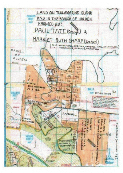
Good news. My techno-genius son has helped me to attach the map of Fawkner's subdivision of section 10, parish of Tullamarine. Notice how many of the 45 lots became part of Paul Tate's "Pleasant Vale", as well as much of 11B and land across Jacksons Creek in the parish of Holden.
Just how wide-spread the Society's purchases on behalf of its members were is illustrated by this article (part of which is not included.)
VICTORIA FREEHOLD LAND SOCIETY.
A Land Distribution will take place at the Society's Office, 38 Collins-street east, on Saturday, Dec, 9th, at three o'clock p.m., when the following members will be entitled to participate in the land undermentioned :-
Moorooduc near Mount Eliza,
- Class A. Mr H.S.Shaw ... 1 Mr. G. C. Young ... 1 John Holland... 1 F. Barnard ... 1 John Grinrod ... 1 W. Green ... 1 John Mason ... 1 P. Jones... 1 J. T. Pender ... 1 G.E.White ... 1 Miss M.M. Anderson... 2
(I have deleted members entitled to land at Caulfield and Emerald Hill i.e. South Melbourne. I have also deleted quite a bit that follows this paragraph and shows how wide-spread the Society's purchases were.)
The Society has recently purchased 60 acres of land suited for market gardens in the parish of Prahran, adjoining Caulfield, which with farms at Kororoit, at Doutta Galla near Essendon , and township lots at Northcote, will be distributed on an early day. (P.8, Argus,8-12-1854.)
Fawkner seems to have started his co-operative in 1849 (when a book of its rules was published.)The above society's Chairman was B.Cowderoy who was involved in its formation in 1853. Whether Cowderoy's group resulted from Fawkner's or not,the convict's son certainly started something!
As Fawkner bought 11B and 22C Doutta Galla,there does seem to be a link between the two societies.